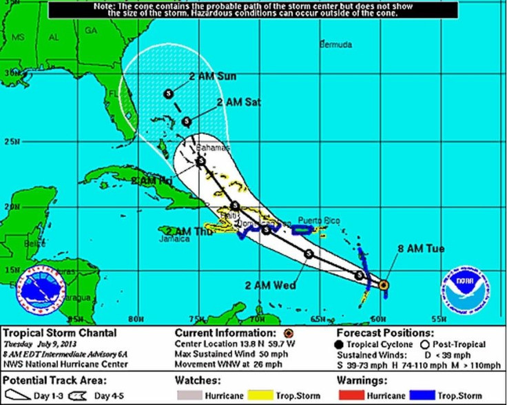
The fast-moving Tropical Storm Chantal is slowly strengthening as it barrels into the Caribbean. Winds are picking up to 60 mph as it moves toward the Dominican Republic, which it is expected to sail by Wednesday. The U.S. National Hurricane Center in Miami said Tuesday morning that the storm is centered about 55 miles northwest of St. Lucia. It is moving west-northwest at a speed of 29 mph. Officials in Dominica are already reporting high winds and heavy rain.
"It's getting rough out there," said Conrad Ceasar, an emergency management official for Dominica's southern region. "Some parts of the island are without electricity."
No injuries have been reported, but the preliminary damage is concerning. The winds have torn roofs off some homes in Dominica. The storm was on a path toward the Eastern Caribbean and is expected to arrive there later Tuesday. The storm could reach hurricane strength by the time it hits Hispaniola, which is shared by the Dominican Republic and Haiti. Both countries are at high risk of flooding, officials said as they mandated school closures and urged residents to stay indoors. This is the third Atlantic hurricane season storm of 2013, Reuters reported.
A tropical storm warning is in effect for St. Lucia, Dominica, Martinique, Guadeloupe, Puerto Rico and the entire coast of the Dominican Republic and the north coast of Haiti. The U.S. Coast Guard in Puerto Rico and the Virgin Islands told those based along waterfronts to clear the area of all debris, hazardous material and pollutants as a safety measure in preparation for the storm. Both areas have been experiencing unusually heavy rainfall since June, according to AccuWeather reports. Both islands have received nearly double the average rainfall for this time of year.
The storm is expected to move toward the Bahamas by the end of the week, according to computer projections. The storm should pass the U.S. by the weekend, though the eye of the storm will be significantly offshore.


© 2025 Latin Times. All rights reserved. Do not reproduce without permission.


