The official Atlantic Hurricane season runs from June 1st through November 30th and while last fall's Hurricane Sandy is still fresh on the minds of all those affected along the eastern coast of the United States, the first tropical storm of the 2013 Atlantic hurricane season is beginning to develop into a significant storm.
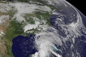
Heading toward the western coast of Florida early Thursday morning, Tropical Storm Andrea is becoming a cause of concern for many states along the east coast. According to USA Today, as of 8am, EDT on Thursday, June 6th, Andrea had winds of 60 miles per hour and was moving in a north-northeast direction at a speed of 14mph. The center of this tropical storm is located some 160 miles west of Tampa.
RELATED: Hawaii Earthquake Hits Big Island With 5.3 Quake; No Tsunami Expected [VIDEO]
Tropical storm warnings were put into effect for most of Florida's west coast including the stretch from Boca Grande to Indian Pass and for certain parts of the East Coast, stretching all the way to Cape Charles Light in Virginia. According to the National Oceanic and Atmospheric Administration (NOAA), there is the potential for tornadoes to develop across parts of Central and Southern Florida throughout the morning and early stages of the afternoon on Thursday.
NOAA also released a report indicating that normally dry areas in parts of Florida could be hit with rising waters due to a strong storm surge while also noting that wind is expected to strengthen as the storm continues to develop.
STORM SURGE...THE COMBINATION OF A STORM SURGE AND THE TIDE WILL
CAUSE NORMALLY DRY AREAS NEAR THE COAST TO BE FLOODED BY RISING
WATERS. THE WATER COULD REACH THE FOLLOWING HEIGHTS ABOVE GROUND
IF THE PEAK SURGE OCCURS AT THE TIME OF HIGH TIDE.
WIND...TROPICAL STORM CONDITIONS ARE EXPECTED TO FIRST REACH THE
FLORIDA WEST COAST WITHIN THE WARNING AREA LATER TODAY...MAKING
OUTSIDE PREPARATIONS DIFFICULT OR DANGEROUS. THESE CONDITIONS WILL
GRADUALLY SPREAD NORTHWARD ALONG THE UNITED STATES EAST COAST
DURING THE NEXT 24 TO 36 HOURS.
You can read the rest of the official Tropical Storm ANDREA Public Advisory HERE.
RELATED: Listen To Dzhokhar Tsarnaev Tell His Mother 'Everything's Fine' From Prison [VIDEO]
Already having produced a significant amount of rain in Mexico's Yucatan Peninsula, the National Weather Service reports that two tornadoes have touched down early Thursday morning in Myakka City, Florida and Sun City Center. Expected to make complete landfall in Florida's Big Bend area, the storm will then move across southeastern portions of Georgia and the Carolinas, according to ABC News. Heavy rains and significant flooding will be the main threats to Georgia and residents should be prepared for isolated tornadoes.
While it is not forecast to develop into a hurricane, Tropical Storm Andrea will bring heavy rain, strong gusts of wind and severe thunderstorms across much of Florida Thursday, so residents are told to be aware of the developing situation while following along with updated weather reports.
Once the storm makes its landfall in Florida and travels to the aforementioned Carolinas, it is expected to continue up the East coast on Friday and Saturday. Touching down along most parts of the Mid-Atlantic to New England, Tropical Storm Andrea will bring pounding rains and strong thunderstorms as it passes through coastal parts of New Jersey, New York, Connecticut Rhode Island and Massachusetts.


© 2025 Latin Times. All rights reserved. Do not reproduce without permission.


