Hurricane Sandy has strengthened to a Category 2 hurricane after beating down on Jamaica on Wednesday.
The hurricane forced the closure of the island's two major airport, which are scheduled to reopen today and at least one person has been reportedly killed. The Hurricane Warning for Jamaica has been discontinued, according to the National Hurricane Center.
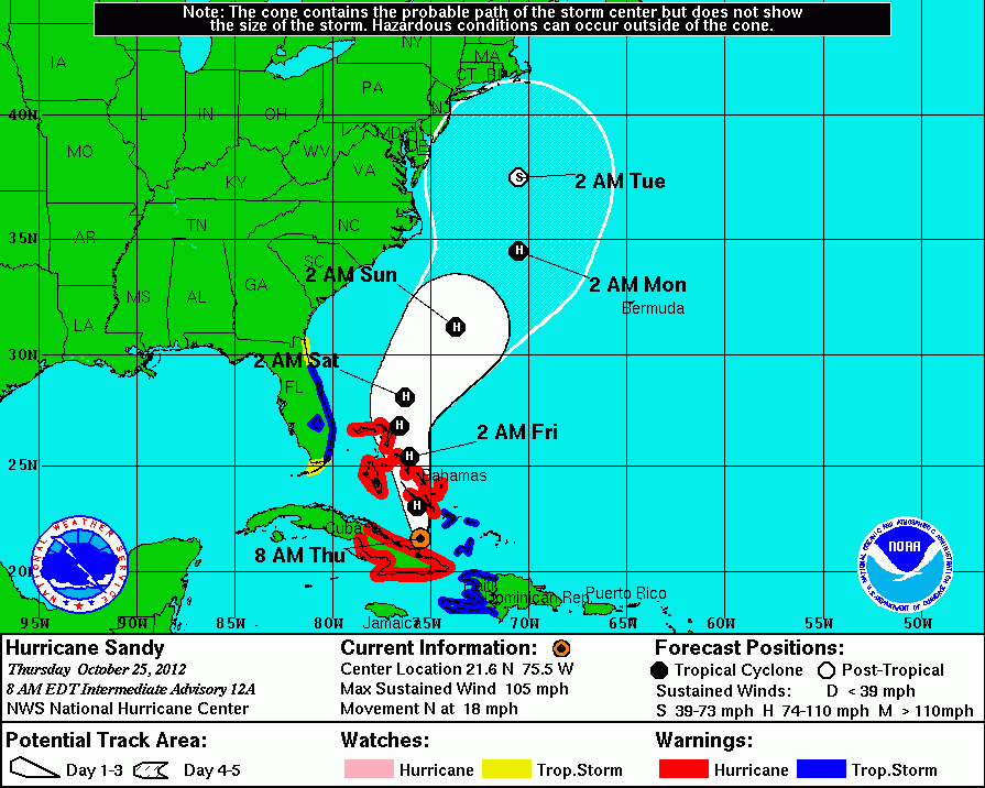
The center has issued hurricane warnings for Cuba and Bahamas. Tropical storm warnings are in effect for Haiti, Florida's coast and a tropical storm watch is in effect for most of Florida.
Sandy claimed one life in Haiti.
The hurricane center said Sandy made landfall on Cuba's northeast coast around dawn and was moving north at 18 mph, with maximum sustained winds of 105 mph.
In the United States, majority of the East Coast is preparing for strong winds, flooding, heavy rain, and snow associated with Sandy.
"It'll be a rough couple days from Hatteras up to Cape Cod," forecaster Jim Cisco of the National Oceanic and Atmospheric Administration prediction center in College Park, Maryland said, according to the AP. "We don't have many modern precedents for what the models are suggesting."
The East Coast from Washington to New York are is expected to be affected.
"A very complicated situation is going on right now," Gary Best, a meteorologist for Hometown Forecast Services Inc. in Nashua, New Hampshire told BloombergBusinessWeek. "As it moves across the western Atlantic, it is going to encounter a dip in the jet stream. There will be a lot of energy coming in from the West and it may try to capture the storm and pull it into the U.S. coastline."
According to Best, Sandy could make landfall "somewhere from Maryland to Delaware about Oct. 28 or go ashore closer to New York or New England from Oct. 29 to 30."


© 2025 Latin Times. All rights reserved. Do not reproduce without permission.


